UAV Spectral Imaging Index Analyzer
Based on image-level (mosaic) multispectral filter imaging technology, airborne spectral imaging index analyzers based on industrial applications have been developed. Such as Shennong Specvision-A precision agriculture monitoring intelligent system, Dayu Specvision-W water environment monitoring intelligent system, Kunlun Specvision-F precision forestry and grass monitoring intelligent system, etc. It can realize river and lake (water pollution monitoring, suspected pollution source investigation, water ecological disaster monitoring, shoreline environment survey, black smelly water treatment), agriculture (planting status assessment, crop growth monitoring, crop collapse analysis, variable planting spraying, crop yield estimation), forestry and grass (forest physical and chemical parameters, forest structural parameters, forest water and fertilizer stress, forest pests and diseases, grass yield, grass cover, grass disaster, grass. It can provide users with first-hand information references with "one map" and provide technical support to solve users' painful problems. The spectral range, number of channels and performance parameters of the UAV spectral imaging index analyzer is shown in Table 1.
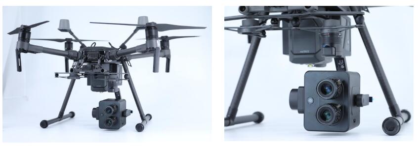
Figure 1 Physical view of the airborne spectral imaging index analyzer
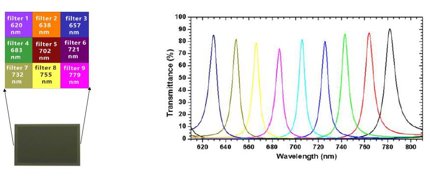
Figure 2 Snapshot spectral imaging principle
Table 1 Main performance parameters of the airborne spectral imaging index analyzer
|
Spectral range
|
460-570nm&640-785nm
(Dual camera default range, can support customization)
|
Number of spectral channels
|
9 (single camera) 18 (dual camera)
|
|
Spectral resolution
|
≤12nm
|
Exposure time
|
28us-1s
|
|
Image resolution
|
1020*1020
|
Adapted to drones
|
Dji M210&M300(Other models can be customized)
|
|
Adaptable heads
|
Dji Xport
|
Minimum working distance
|
20m
|
|
Dimension (L*W*H)
|
85*80*100mm(Lens not included)
|
Built-in computer interface
|
USB3.0+HDMI
|
|
Lens field of view
|
36°(Diagonal)
|
Lens focal length
|
25mm
|
|
Lens Aperture
|
F/4
|
Voltage
|
13.6V
|
|
Power consumption
|
20W
|
POS Data
|
Xport GPS Data
|
|
Storage Devices
|
Embedded MicroSD card, default 64G, maximum support 128G
|
Weight
|
550g(Without Adaptable head)
|
|
Spectral image acquisition rate
|
1:45fps(No real-time model calculation) 2:1~15S/group (real-time model calculation)
|
Image storage format
|
10bit RAW+HDR;Spectral images + index results
|
|
Real-time inversion index available
|
Online models of 25 vegetation indices such as NDVI, EVI, NDVI705, SAVI, RVI and many other indicators of water bodies
|
Industrial application areas (including but not limited to the following):
1) Eco-environmental protection: water pollution monitoring, suspected pollution source investigation, watershed ecological disaster monitoring, shoreline environmental survey, black smelly water treatment, etc.
2) Precise agriculture: planting condition assessment, crop growth monitoring, crop collapse analysis, variable plant protection spraying, crop yield estimation, soil heavy metal detection, soil fertility assessment, etc.
3) Precision forestry and grass: forest physical and chemical parameters, forest water and fertilizer stress, forest pests and diseases, forest classification, grass cover, grass disaster, grass degradation, etc.
4) Target identification: pines nematode alien wood identification, poppy discrimination, camouflage discrimination, etc.
5) Smart city: housing violation, urban vegetation coverage, urban grid exploration, water resource management, etc.
6) Rresource exploration: petroleum exploration, non-ferrous metal prospecting, rock and ore detection, etc.Industry application examples.
Eco-friendly spectral imaging index analyzer
Relying on spectral imaging technology, it strongly assists to intelligent environmental protection. Based on years of technology accumulation, Spectrum Vision strongly launches Dayu Specvision-W water environment monitoring intelligent system, which can accomplish real-time monitoring for applications such as water pollution monitoring, suspected pollution source ranking, watershed ecological disaster monitoring, shoreline environmental investigation, and black smelly water treatment. It can also obtain real-time distribution results of more than 20 water body indicators such as total nitrogen, total phosphorus, chlorophyll a, suspended solids, potassium permanganate index, algae distribution and eutrophication index, truly realizing real-time and efficient online analysis and monitoring of the water environment.
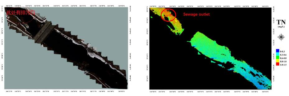
Figure 2 UAV spectral imaging index analyzer monitoring river plant outfalls
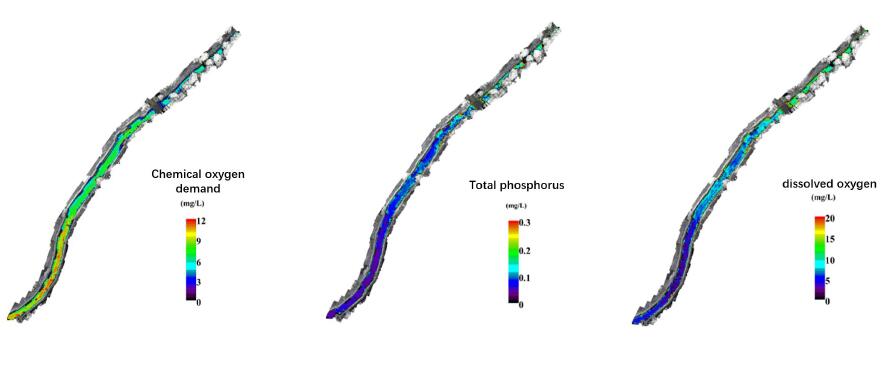
Figure 3 UAV spectral imaging index analyzer monitoring river water quality conditions
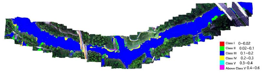
Figure 4 UAV spectral imaging index analyzer judging the water quality level of rivers and lakes

Fig. 5 Distribution of eutrophic status of Liangxi River as discerned by UAV spectral imaging index analyzer
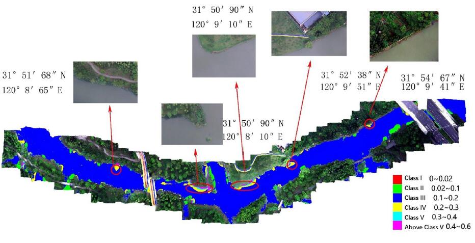
Figure 6 UAV hyperspectral combined with auxiliary camera shots of the river's surrounding environment to identify suspected river pollution sources
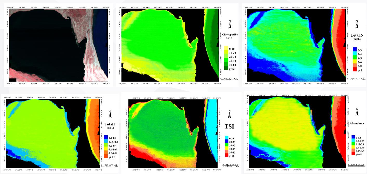
Figure 7 UAV spectral imaging index analyzer to judge the lake water quality status
Fine Agriculture Spectral Imaging Index Analyzer
Relying on spectral imaging technology, it strongly helps precision agriculture. Based on years of technology accumulation, Spectrum Vision strongly launches Shennong Specvision-A precision agriculture monitoring intelligent system, which can realize real-time monitoring of planting condition assessment, crop growth monitoring, crop collapse analysis, variable plant protection spraying, crop yield estimation and other applications. At the same time, it can obtain real-time online distribution of crop growth, collapse and yield in the target area, and provide first-hand information reference for field production with "one map", so as to realize intelligent management of agriculture in a real sense.
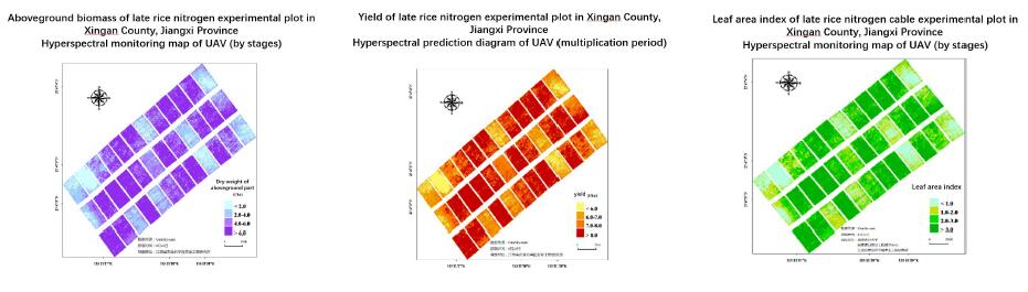
Figure 1 Monitoring crop growth and yield based on airborne multispectral imaging system
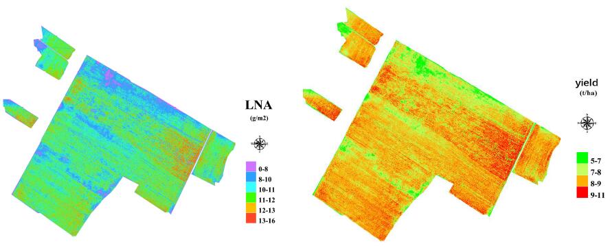
Figure 2 Monitoring crop growth and yield based on airborne multispectral imaging system
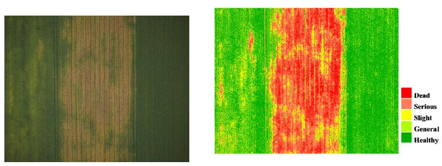
Figure 3 Classification of crop disease classes based on multispectral imaging system
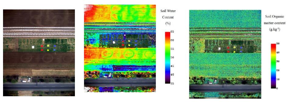
Figure 4 Distribution of soil water content and soil organic matter content detection based on multispectral imaging system
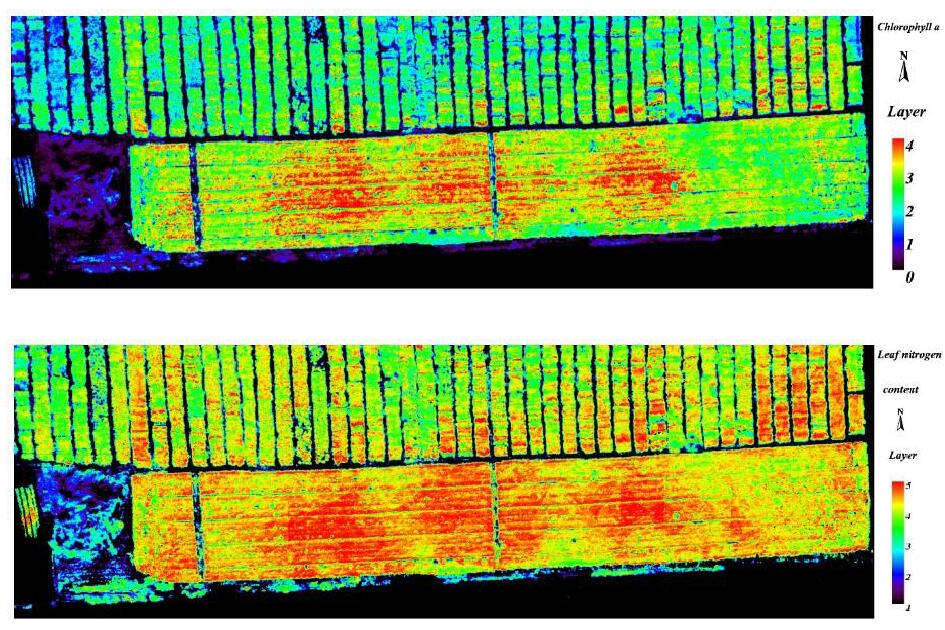
Figure 5 Monitoring crop growth based on UAV spectral imaging index analyzer
Fine Forest and Grass Spectral Imaging Index Analyzer
Relying on spectral imaging technology, it strongly contributes to accurate forestry and grass. Based on years of technology accumulation, Spectrum Vision strongly launches Kunlun Specvision-F accurate forest and grass monitoring intelligent system, which can realize real-time monitoring of forest physical and chemical parameters, forest structural parameters, forest water and fertilizer stress, forest pests and diseases, grass yield, grass cover, grass disaster, grass degradation, grass nutrition and other applications. At the same time, it can obtain real-time online distribution of forest and grass growth, physical and chemical parameters, yield, etc. in the target area, and provide customers with first-hand information reference with "one map", so as to realize intelligent management of forest and grass in real sense.

Fig. 1 Spectral index analysis of forest trees by UAV spectral imaging index analyzer
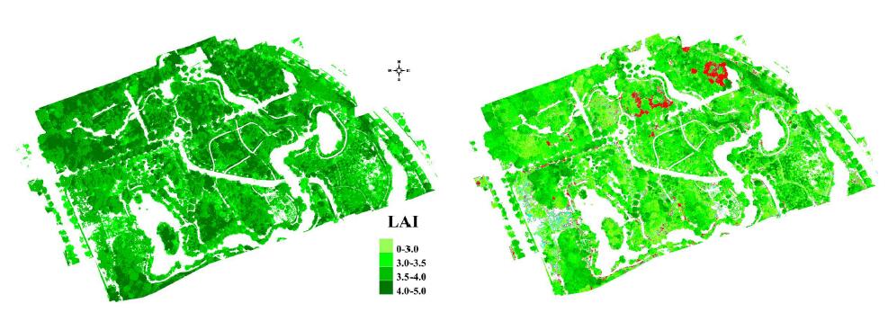
Fig. 2 Analysis of leaf area index of forest trees and location of epidemic trees by UAV spectral imaging index analyzer (red part)Fig. 1 Spectral index analysis of forest trees by UAV spectral imaging index analyzer
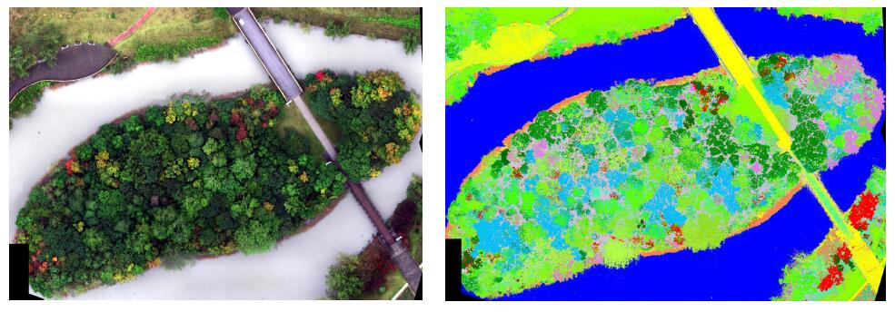
Figure 3 UAV spectral imaging index analyzer to analyze canopy size and tree species
Tobacco Spectral Imaging Index Analyzer
China is a major tobacco growing country, tobacco is planted in all provinces of the country, its area and production are currently the world's largest, tax revenue in China's total tax revenue occupies a pivotal position, and has made considerable contributions to China's economic development. And China's total production of tobacco accounted for more than 80% of roasted tobacco, is the most important raw material for the production of cigarettes. For a long time, China has been using time-consuming, labor-intensive and costly traditional methods to observe and monitor the growth and quality of tobacco in tobacco fields. UAV spectral imaging technology is an efficient tobacco planting management tool, which can provide decision makers with fast and accurate tobacco growth conditions on a large scale and provide effective data for fertilization, irrigation and pesticide spraying, which can significantly improve the level of pesticide modernization and promote sustainable development of modern agriculture. Therefore, UAV spectral imaging technology has greater application value in tobacco field monitoring, and is a recent trend in tobacco field management.
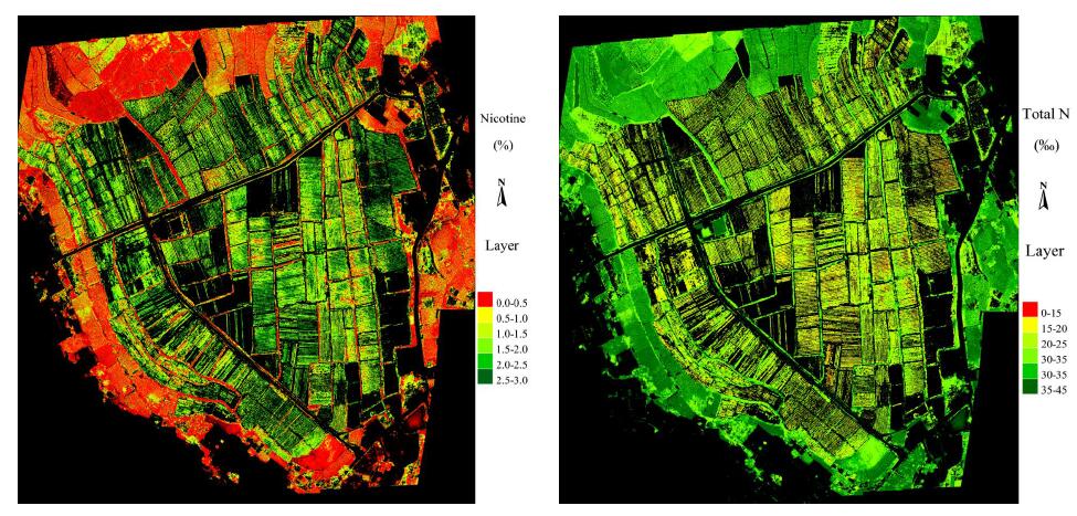
Figure 1 Inverse diagram of total nitrogen and nicotine of tobacco chemical composition at Shibanqiao tobacco base in Yunnan

 13910278534
 010-56370168