GaiaSky-mini based monitoring of heavy metal contamination in agricultural soils
With the progress of science and technology, the crop yield of arable land is rising day by day. However, the abuse of large quantities of pesticides and chemical fertilisers, as well as the irrational use of mineral resources, etc. have brought serious heavy metal pollution to the soil. Heavy metals can generally only undergo morphological transformation and migration in the soil, are sometimes difficult to degrade, are difficult to manage anthropogenically, and tend to circulate and accumulate in the food chain. It can affect the development of plant roots and leaves, and damage the human nervous system, immune system and skeletal system, posing a major threat to both the ecological environment and human health. Therefore, the exploration of rapid, real-time, accurate and low-cost technical means to monitor heavy metal pollutants has been a popular topic of research at home and abroad. The traditional method for identifying the content of heavy metals in soil is to sample the soil in the field and then measure the content of various heavy metals in the laboratory. The accuracy of this method is high, but the analysis period is long and the cost is astronomical, so it is not suitable for large scale periodic monitoring. Hyperspectral remote sensing data has hundreds of wavelength bands. The spectral resolution is above the nanometre level, and the tens of thousands of band combinations brought about by multiple bands contain a huge amount of information, and at the same time, due to the extremely high spectral resolution, near-continuous spectral information can be obtained. Therefore, by extracting the characteristic waveform of a feature. This provides for the identification of features and the inversion of their composition, making a qualitative leap from macroscopic qualitative research to microscopic quantitative research.
Kemper et al. used soil reflectance spectroscopy to invert the content of Cr, Hg, Pb, Cu and Zn in the soil of the Aznalcollar mine, and achieved good predictions for Hg and Pb, but the accuracy of predictions for Cu, Zn and Cr was not satisfactory. Woitke et al. studied the heavy metal content of the Danube sediment and concluded that the contamination of Cd was more serious. Xia Fang et al. used the visible-near-infrared reflectance data and heavy metal and organic matter content data of soil samples to predict the contents of Ni, Cu, As, Hg, Zn, Cr, Cd and Pb in the cultivated layer of 643 agricultural fields in 36 counties and cities in Zhejiang Province, which provided a basis for regional remote sensing monitoring of heavy metals in soil. Zhang Qiuxia et al. used a panel data model to predict the heavy metal contents of 191 cultivated soil samples in Xinzheng City, which was easy and fast to calculate. At this stage, there are relatively few studies using airborne hyperspectral data for soil heavy metal monitoring, and the accuracy of monitoring heavy metal content in large areas needs to be further improved. This study explores the feasibility of using airborne hyperspectral remote sensing data to predict the heavy metal content of wetland soils on a large scale based on GaiaSky-mini airborne hyperspectral imagery data, combined with the spectral data of soil samples collected by ASD and heavy metal content data from chemical detection.
1.Overview of the study area
Guiding County is situated in Qiannan Buyi Miao Autonomous Prefecture, with a total area of 1631 km2. 107°08'E-107°15'E, 26°40'N-26°47'N. Guiding County belongs to the monsoon climate zone, with distinct seasonal alternations and an average annual temperature of 15.5 ℃; average annual precipitation is 1084.8mm. Mineral resources in guiding county mainly include coal mines, iron ore and electric limestone mines. The county has an arable land area of about 13,233.4 hm2, which is mainly low and medium farmland, with a lot of forgettable mountainous land, suitable for the comprehensive development of agriculture, forestry and animal husbandry.
2 Data
2. 1 Hyperspectral image data
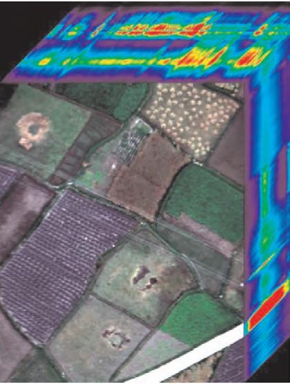
On 17 May 2017, around noon, the weather was clear, with few clouds and low wind, hyperspectral images were collected with a GaiaSky-mini (hereafter referred to as GS) hyperspectral imaging system in Yanxia Township, Guiding County, on a farmland to be sown in the study area with a relatively flat soil surface (Fig. 1). The GS series is an unmanned hyperspectral camera developed by Jiangsu Shuangli Hepu Technology Co.,Ltd. It is now used in military applications such as target identification, camouflage and counter-camouflage, as well as ground object and water body telemetry, modern fine agriculture and other ecological monitoring.
2.2 Sampling and sample preparation
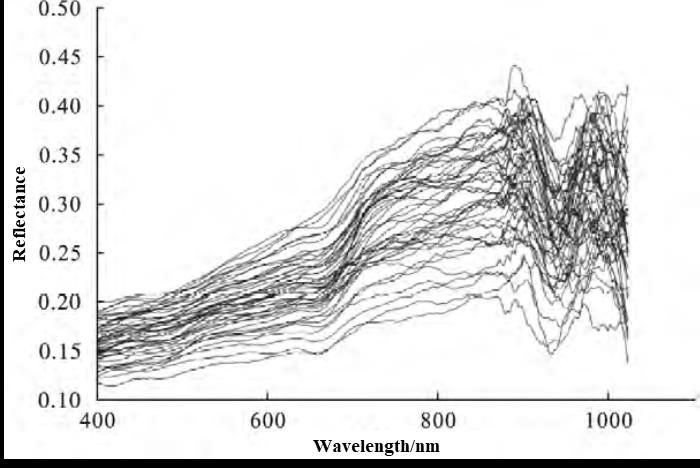
On 23 April 2017, 25 soil samples were collected from each of the two experimental fields at 10 m and 5 m, according to the actual topography, in accordance with the isometric sampling method inside two agricultural fields in Yanxia Township, Guiding County, for a total of 50 soil samples ( Fig. 2). Soil samples were collected in polythene bags from the top 0 to 20cm. Each sample was 1kg, closed and marked with a marker. The soil samples were set out on clean kraft paper and dried naturally to remove any gravel, plant debris, etc. from the soil. After air-drying the soil samples are ground with a wooden stick, passed through a 2mm nylon sieves and mixed well. Soil samples are further ground with an agate machine, passed through a 2mm nylon sieves, then through a 100 mesh nylon sieves, mixed and ready for use.
2. 3 Chemical analysis and spectroscopic measurements
Data relating to the heavy metal content of the soil samples were obtained from laboratory chemical assays. Cd and Pb were measured by graphite furnace atomic absorption with detection limits of 0.01 mg-kg-1 for Cd and 0.1 mg-kg-1 for Pb; Hg and As were measured by atomic fluorescence with detection limits of 0.002 mg-kg-1 for Hg and 0.01 mg-kg-1 for As; Cr was measured by atomic absorption spectrophotometry with a detection limit of 5 mg-kg-1 for Cr. 2 GS spectrum analysis
Fig.1 GaiaSky-mini image map cube
Fig.2 GaiaSky-mini original spectral reflectanc
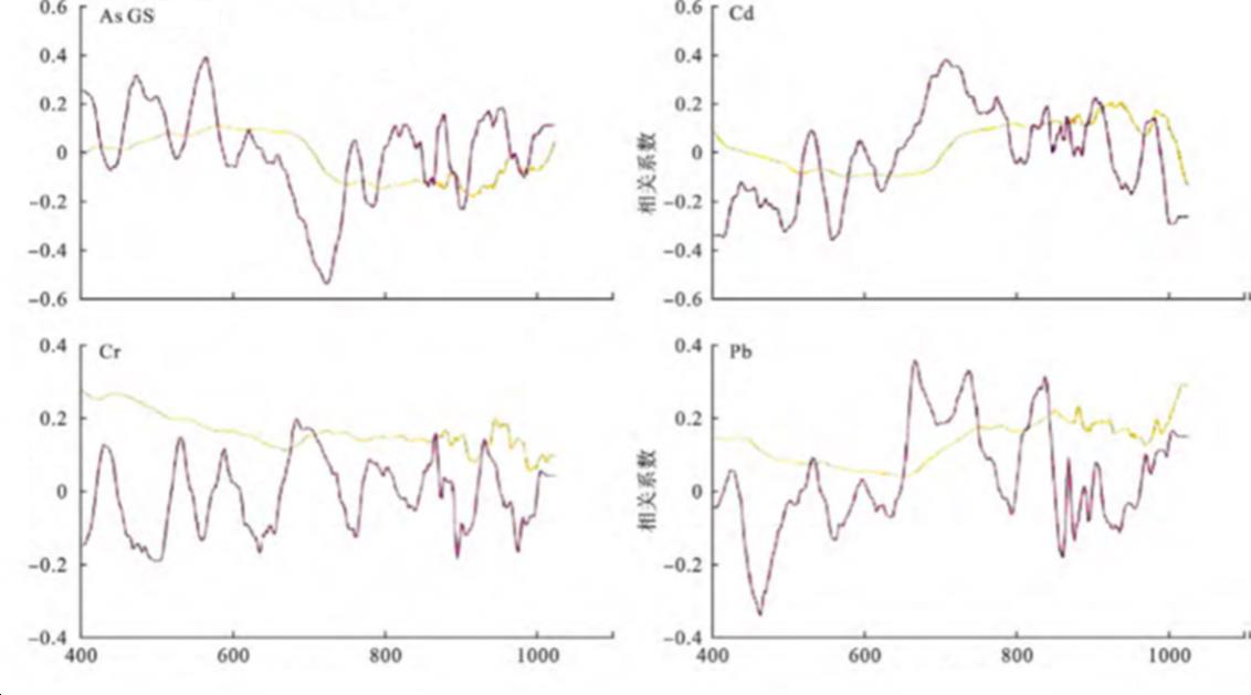
The GS spectra is not effective in the removal of continuum, so no correlation analysis was done. However, the GS spectrum has slightly more sensitive bands for Pb than for Cr. Due to the limitations of the spectral range of the sensors, the spectral ranges of the five heavy metal were all in the visible and near-infrared bands. Pb is sensitive at 451, 671, 673 and 735nm, with a maximum correlation coefficient of 0.419. The main reason is that Hg is too low in this region and there are almost no sensitive bands, so we will not make the relevant spectral analysis for Hg elements later. Table 1 shows in the modelling analysis for the spectral estimation of heavy metal content based on GS spectral.
Fig.3 GS spectra associated with four heavy metal levels
Table1 Estimated spectral model parameters for soil heavy metal contents
data source
|
element
|
PC
|
Modeling set
|
Validation Set
|
|
|
|
Modeling sample
|
Rm2
|
RMSEm
|
Validation sample
|
Rv2
|
RMSEv
|
RPD
|
GS
|
As
|
3
|
32
|
0.49
|
0.161
|
15
|
0.36
|
0.180
|
1.13
|
Cd
|
4
|
32
|
0.36
|
0.033
|
15
|
0.71
|
0.023
|
1.50
|
Cr
|
3
|
32
|
0.27
|
8.308
|
15
|
0.11
|
8.826
|
0.88
|
Pd
|
3
|
32
|
0.46
|
2.476
|
15
|
0.16
|
2.838
|
1.00
|
3 Results and discussion
The application of GS spectroscopy can provide technical support for rapid monitoring and contamination evaluation of soil heavy metal content in agricultural fields on a large scale, and provide technical and theoretical support for further application of airborne or satellite-based hyperspectral remote sensing for quantitative monitoring of soil heavy metal contamination. There are still many objective factors that have yet to be resolved in the field monitoring of soil heavy metal content. When acquiring GS spectral data, the influence of meteorological conditions such as wind size, solar altitude angle, cloud limit or the particle size of the soil itself, the flatness of the soil surface, moisture content, etc. can affect the acquisition of spectral data

 13910278534
 010-56370168